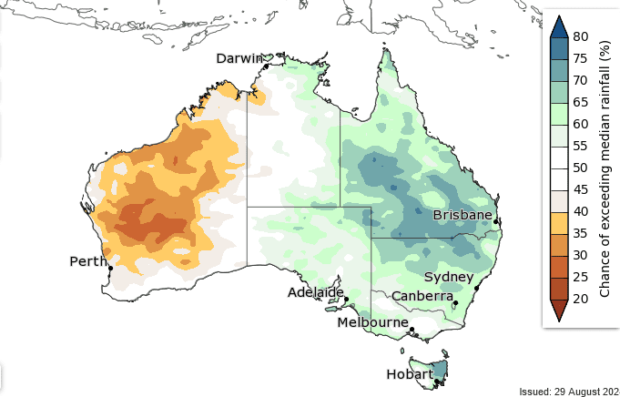
Chances of exceeding median rainfall to December. Image: Bureau of Meteorology
THE Bureau of Meteorology has released its 2024 Spring Long-Range Forecast, predicting warmer-than-average temperatures and mixed chances of achieving median rainfall.
The long-range forecast provides guidance on the likelihood that different parts of the country will see conditions that are warmer or cooler, or wetter and drier than average over the next three months.
The Spring Long-Range Forecast shows an increased likelihood of warmer than average temperatures across all states and territories this spring.
Rainfall forecasts are more mixed, with an increased likelihood of above average for large parts of eastern Australia, and more likely below average rainfall for large parts of Western Australia.
The Long-Range Forecast is updated weekly with the forecast accuracy steadily improving as the start of the next month approaches.
It is worth noting that spring is typically a time when southern Australia experiences large swings in weather associated with passage of cold fronts across the south, as well as more thunderstorm activity as the weather warms.
Spring forecast by state and territory
New South Wales and the ACT
Most of NSW and the Australian Capital Territory have increased chances of warmer-than-usual spring temperatures.
Parts of eastern NSW, including around Sydney, are likely to see temperatures in the typical range for spring.
Most of NSW and the ACT have increased chances of above-average spring rainfall.
There is also an increased chance for unusually high spring rainfall for most of the northern half of the state, extending into some central areas.
Spring rainfall in recent decades has typically been 100-300mm along the east coast and 25-100mm in western NSW.
Victoria
Vic has an increased chance of warmer-than-usual spring temperatures.
Most of Vic is likely to have rainfall within the typical range for spring.
This follows several very dry months in the west of the state.
There is a slightly increased chance of above-average spring rainfall for a part of the state’s south-west.
Queensland
All of Qld has an increased chance of warmer-than-usual spring temperatures with an increased chance of unusually warm days and nights for most of the state.
Most of Qld is likely to have above-average rainfall, especially southern and central areas.
Northern Australia’s official wet season begins in October.
The first significant rains of this northern wet season are likely to be earlier than usual for most of Qld.
Western Australia
Most of WA has an increased chance of warmer-than-usual spring temperatures with an increased chance of unusually warm days and nights in some northern areas.
Perth and parts of the state’s south can expect average daytime temperatures for spring.
Rainfall in south-west WA, including Perth, is likely to be within the typical range for spring.
Spring rainfall has typically been 50-300mm in recent decades for most of the South West Land Division.
Below-average rainfall is likely in parts of the mid-west and central inland regions.
Northern Australia’s official wet season begins in October.
The first significant rains of this northern wet season are likely to be later than usual for most of WA’s northern areas.
South Australia
SA has an increased chance of warmer-than-usual temperatures across spring.
Adelaide, parts of the state’s southern agricultural areas and parts of the north have a slightly increased chance of above-average spring rainfall.
This follows a prolonged period of dry conditions that have prevailed in the south-east of the state this year.
The forecast shows a more typical range of spring rainfall is likely for the rest of the state.
Tasmania
Tas has an increased chance of warmer-than-usual spring temperatures with an increased chance of unusually warm days and nights.
There is a higher chance of above-average spring rainfall for eastern Tasmania.
There is an increased chance for unusually high spring rainfall in parts of the east.
Western Tas is likely to have rainfall within the typical range for spring, noting that recent rainfall has helped alleviate dry conditions experienced during autumn and winter.
Northern Territory
All of the NT has an increased chance of warmer-than-usual spring temperatures with an increased chance of unusually warm days and nights for most areas.
The forecast shows that a typical range of spring rainfall is likely for most of the Territory.
Northern Australia’s official wet season begins in October.
The first significant rains of this northern wet season are likely to be earlier than usual for parts of the Top End.
Winter – preliminary summary
Despite some typically cool winter temperatures at times on the east coast, winter has been warmer than usual across the country, with August on track to be Australia’s warmest August on record.
While winter rainfall has been close to average for many areas, parts of Australia’s south-east have been drier than usual.
Overall, Australia’s mean temperature will be around 1.5 degrees Celsius above the 1961-1990 winter average.
The national summary for winter and August will be on the Bureau’s website from September; detailed summaries for winter and August conditions for each state and capital city will be published September 4.
Source: Bureau of Meteorology